This blog post is part of a series on the 2019 Graedel Prize Winners.
Read the other blog post here: An indicator framework for monitoring progress towards a circular economy.
Click here to view the original paper.
From the parcel containing your latest online purchase to the concrete and steel that make up skyscrapers, our urban environment is awash with materials. Understanding how such materials flow through our cities is the important first step to designing future cities that use resources more efficiently and with less environmental impact.
One method we can use to achieve this understanding is through Material Flow Analysis (MFA), which balances the inputs and outputs of materials within a predefined system ‒ in our case, a city. However, this approach tends to reduce the city into a “black box”, causing us to lose sight of the internal processes of the city, such as the drivers of material use, or recycling.
The use of freight data is highly relevant in understanding urban material flows. Coupled with technological advancements in data collection and computing (most notably the modern smartphone), we now have a great opportunity to study urban material flows in greater detail. We demonstrate the potential of high‐resolution commodity flow and freight transport data with two case studies in the United States and the city-state of Singapore. For brevity, we will focus on the Singaporean case study.
Truck driver activity data in Singapore
We use data from a GPS-based truck driver activity survey in Singapore that was conducted over five days in the period of 2017/2018. Trajectory data of the trucks provided by on-board GPS devices were used to infer the truck’s stops and activities, which were then presented to the driver for validation. The driver then provided additional information, such as the type and volume of goods picked up or delivered.
With a sample of 173 vehicles carrying construction materials, we spatially aggregated the pickup and delivery volumes into a hexagonal grid, allowing us to see the net accumulation or removal of materials across the city.
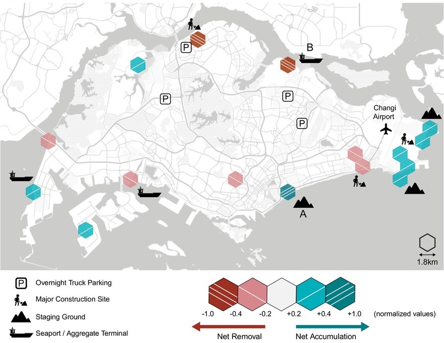
Net accumulation and removal of construction‐related materials in Singapore by spatially aggregating the data into a hexagonal grid.
Through the map above, we observed a net removal of construction materials and minerals from major construction sites that involve excavations and at specific aggregate terminals (e.g. Location B). This is followed by a corresponding net accumulation of the material at staging grounds, most notably at Location A.
To get a closer look at the relations between the identified locations, we mapped the flows towards Location A, which had the highest magnitude of net accumulation. This led to the figure below, in which we see large flows from the staging ground at Location B and a major construction site in the east.
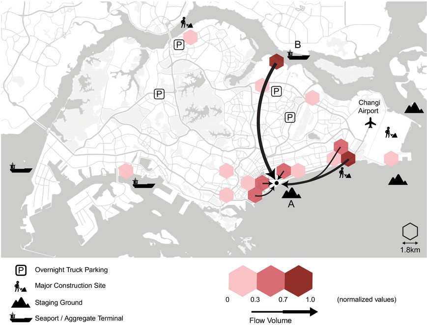
Origins of construction‐related material flows toward Location A.
As it turns out, a large driver for the flows we observed is the reuse of excavated materials for land reclamation. In addition to imported material, which is received at aggregate terminals or seaports, materials from major construction sites are moved by dump trucks into staging grounds. These staging grounds serve as temporary storage areas or as loading points for barges to bring the material out to sea for land reclamation, which explains their location along the coast.
Toward high‐resolution urban material flow analysis
The Singaporean case study is one example of how high-resolution freight data allows us to peer into the “black box”, uncovering the internal processes within a city. In this case, the reuse of excavated materials for land reclamation as a driver for material flows and an example of secondary sourcing of material.
There are opportunities for improvement in moving towards high-resolution urban material flow analysis. In addition to the spatial dimension, material flows also have a temporal aspect. Conducting analyses with greater temporal resolution could allow us to capture the transformations of materials throughout their life cycle. Additionally, datasets could be fused and layered to form a more complete picture of the drivers behind the material flows we observe. Still, we must keep in mind that all these possibilities rely heavily on how data is collected and accessed, while still preserving the privacy of stakeholders.
Personal Note
I am immensely honoured to be awarded the Graedel Prize. This paper would not have been possible without the support of our research sponsors and the anonymous reviewers whose comments improved the arguments and presentation of the paper. Much gratitude goes towards my supervisor, Professor Lynette Cheah for her ideas and support throughout the entire process. Credit goes to Dr Ate Poorthuis for reviewing the visualisations and Dr Linlin You and Fangping Lu for their support in data collection.
